China’s Aircraft Carrier Fujian in the Taiwan Strait
Background
-
Fujian (Type 003): China’s third and largest aircraft carrier, conventionally powered.
-
Launched in 2022, undergoing sea trials before commissioning.
-
Features electromagnetic catapult system (EMALS) → comparable to US carriers, enhancing aircraft launch efficiency.
Recent Development
-
Fujian sailed through Taiwan Strait for the first time, heading toward South China Sea for training & scientific experiments.
-
China claims it was the “most reasonable route,” not directed at anyone.
-
Accompanied by two guided-missile destroyers.
-
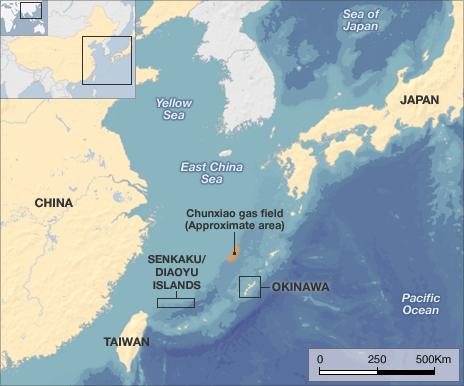
Japan’s Self-Defense Forces spotted the carrier near the Senkaku/Diaoyu islands.
Regional & Global Reactions
-
Taiwan Strait:
-
Highly sensitive, separates China from Taiwan.
-
U.S. & allies regularly conduct “freedom of navigation” transits here.
-
-
U.S. & Allies:
-
U.S. Navy conducts regular passages to counter Beijing’s sovereignty claims.
-
Recently, Canadian frigate Quebec & Australian destroyer Brisbane passed through; China accused them of provocation.
-
-
Japan:
-
Monitored Fujian near disputed Senkaku/Diaoyu Islands, reflecting rising East China Sea tensions.
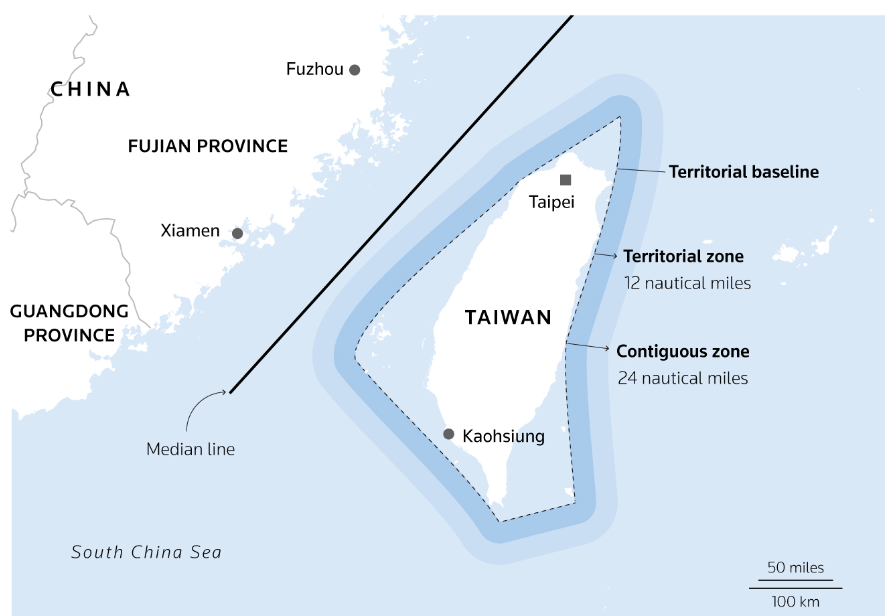
Taiwan Strait
Geography
-
Location: Separates Taiwan Island from Fujian Province (China).
-
Part of: South China Sea (to the south), connects to the East China Sea (to the north).
-
Length / Width: ~180 km wide; narrowest point ~130 km.
-
Depth: Mostly <150 m (continental shelf).
-
Islands:
-
PRC-controlled: Xiamen, Gulangyu, Pingtan (Haitan).
-
ROC-controlled: Kinmen, Matsu, Penghu (Pescadores).
-
Names
-
Former: Formosa Strait, Strait of Fokien/Fujian, Black Ditch (Hokkien/Hakka).
Boundaries
-
North: Line from Fujian coast → Haitan Island → Fugui Cape (Taiwan).
-
East: Western coast of Taiwan down to Eluan Cape (southern tip).
-
South: Eluan Cape → Nanao Island → Hanjiang River mouth (China).
-
West: Fujian coast from Hanjiang River → north to Haitan.
The "Median Line" (Davis Line, 1955)
-
Proposed by U.S. Gen. Benjamin O. Davis Jr. (1955).
-
Tacit understanding (not legally recognized).
-
Coordinates: ~27°N, 122°E (north) → 23°N, 118°E (south).
-
Taiwan recognizes it; China rejects it.
-
Since 2019, PLA aircraft regularly cross it, nullifying old status quo.
Geopolitical Significance
-
Flashpoint: Central to China–Taiwan conflict; PRC considers Taiwan part of its territory.
-
US role: U.S. Navy + allies conduct Freedom of Navigation Operations (FONOPs) through strait.
-
Military Escalation: Frequent Chinese naval & air drills, especially post-2019.
-
Strategic Location: Controls access between East & South China Seas; vital for Indo-Pacific shipping.