Forest Cover, Tree Cover, and Forest Land
×
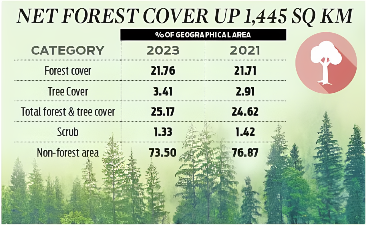
![]()
1. Forest Cover
| Feature | Details |
|---|---|
| Definition | All land more than 1 hectare in area with a tree canopy density of more than 10%, regardless of ownership, legal status, or land use. |
| Includes | Natural forests, plantations, orchards, bamboo groves, etc. — even outside legal forest areas. |
| Measured by | Satellite imagery by Forest Survey of India (FSI). |
| Example | Coffee plantations or mango orchards with dense tree canopy may be counted as forest cover. |
| Latest Status | As per ISFR 2023, India’s forest cover is 21.76% of total geographical area (~7.15 lakh sq. km). |
2. Tree Cover
| Feature | Details |
|---|---|
| Definition | Tree patches less than 1 hectare in area, including trees outside recorded forests such as along roads, canals, in urban areas, farmlands, parks, home gardens. |
| Includes | Avenue trees, agroforestry, scattered fruit trees. |
| Measured by | Sample-based assessments by FSI, not satellite-based. |
| Example | Neem trees along highways or trees in private courtyards. |
| Latest Status | Tree cover of India is about 3.41% of total geographical area (~1,12,014 sq. km as per ISFR 2023). |
3. Forest Land (Recorded Forest Area)
| Feature | Details |
|---|---|
| Definition | Land legally notified as forest under Indian Forest Act, 1927 or under any State Forest Act — regardless of tree cover. |
| Includes | Reserved Forests, Protected Forests, Unclassed Forests. |
| May or may not have trees? | Yes. A barren rocky land legally notified as forest is still "forest land". |
| Administered by | Forest Department of State Governments. |
| Example | A dry, scrubland declared as Reserved Forest by a state government. |
| Latest Status | India’s Recorded Forest Area is around 25.17% of total geographical area (~8.27 lakh sq. km). |
Key Differences
| Feature | Forest Cover | Tree Cover | Forest Land |
|---|---|---|---|
| Basis | Tree canopy density >10% | Tree patches <1 ha | Legal notification/status |
| Includes | All vegetative cover >1 ha | Small patches outside forests | Even barren or non-vegetated forest area |
| Source | Satellite (FSI) | Sample survey (FSI) | Legal records (State Govts) |
| Relation with Trees | Must have trees | Must have trees | May or may not have trees |
| Governed by | MoEFCC via FSI | MoEFCC via FSI | State Forest Departments |