Great Assam Earthquake, 1950

The quake occurred along the boundary where the Indian and Eurasian Plates collided, near the eastern terminus of the Himalayas, at a depth of 15 km.
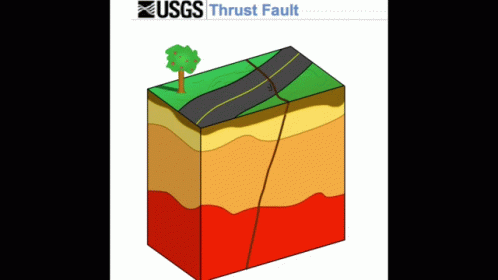
The rupture extended from the Mishmi thrust of the Eastern Himalayas to the Himalayan Frontal Thrust of Arunachal Pradesh, completing a curvilinear motion around the mountainous bend
Date & Magnitude
-
Occurred 15 August 1950, ~7:30 pm
-
Magnitude 8.6 – strongest recorded earthquake on land
-
Duration: 4–8 minutes shaking
-
Epicentre: ~40 km west of Rima (Zayu), Mishmi Hills, India–Tibet border
-
Depth: ~15 km
Impact
-
Felt over 3 million sq. km (India, Myanmar, Bangladesh, Tibet, South China)
-
Deaths: >1,500 in India; ~4,000 in Tibet
-
Cattle deaths: 50,000–1,00,000
-
Infrastructure destruction: railway tracks twisted, bridges collapsed, hills sheared, homes/farms destroyed
-
Secondary hazards: landslides blocked rivers → flash floods after dam bursts (Brahmaputra flood)
-
Widespread damage in Sibsagar–Sadiya (Assam) and Medog (Tibet)
Tectonic Setting
Due to plate rotation, major structural elements also take sharp turns, and the regional strike shifts from the general NE-SW direction to the NW-SE direction post-collision, forming what geologists call the Eastern Himalayan Syntaxis (EHS).
-
Occurred along Indian–Eurasian Plate boundary at the Eastern Himalayan Syntaxis (EHS)
-
Plate convergence rate: 10–38 mm/year (Eastern Himalayas)
-
Involves Indian Plate, Eurasian Plate, and Sunda Plate interaction → complex tectonics
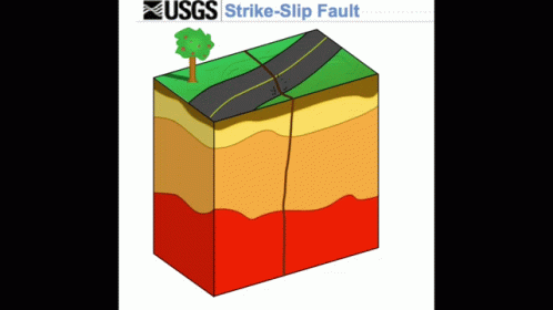
- Unlike typical thrust earthquakes in the Himalayas, the 1950 quake had a strike-slip component (lateral movement)
-
Likely rupture from Syntaxial bend + activation of Himalayan thrust faults westward
-
Aftershocks: widely distributed east of main epicentre
Historical Seismicity
-
Records of major earthquakes in region: 1548, 1596, 1697 (Ahom period)
-
Geological evidence: major medieval quake between 1262–1635 AD
Significance
-
Provided early instrumental data
India had the Meteorological Department (IMD) set up its first seismological observatory at Alipore in Kolkata district in 1898.
-
Enhanced understanding of Himalayan plate tectonics & seismic risk
Future Risk
-
Central & Eastern Himalayas remain highly seismically active
-
Magnitude ≥8.6 quakes possible along the 2,500 km Himalayan arc
-
Rising vulnerability due to urban growth, infrastructure (esp. dams) in fragile zones
Policy & Preparedness Lessons
-
Development in tectonically sensitive areas must consider seismic hazard mapping
-
Hydroelectric projects in Eastern Himalaya require rigorous seismic risk assessment
-
No prediction possible for exact timing/location – need for long-term resilience planning