Seismic Microzonation in India
What is Seismic Microzonation?
-
Seismic microzonation refers to subdividing a region into zones with different potential levels of seismic hazard, based on geological, seismological, geotechnical, and engineering characteristics.
-
It helps in preparing location-specific mitigation strategies for earthquake-prone areas and is crucial for urban planning, infrastructure design, and disaster preparedness.
Recent Developments (as per MoES – August 2025)
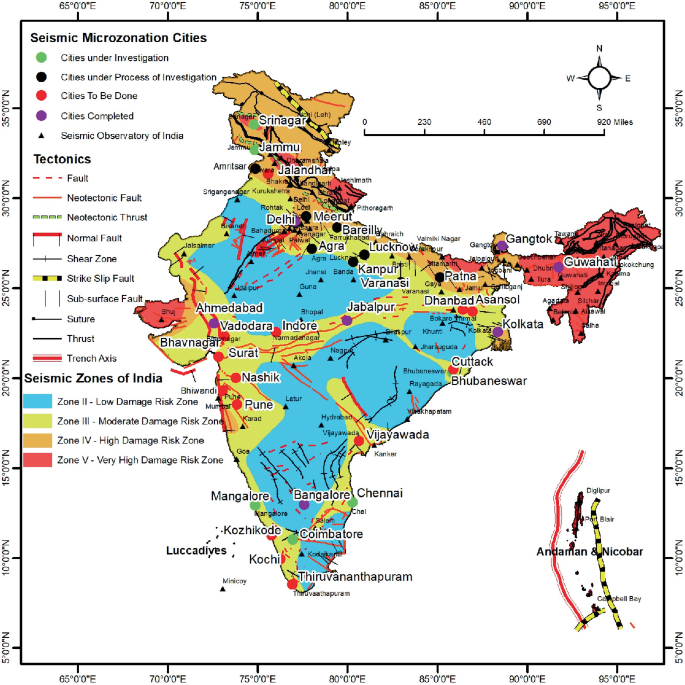
Cities Already Covered:
-
Metro & Major Cities:
-
Delhi
-
Bengaluru
-
Kolkata
-
Guwahati
-
Jabalpur
-
Dehradun
-
Ahmedabad
-
Gandhidham
-
-
South India:
-
Chennai
-
Coimbatore
-
Bhubaneswar
-
Mangalore
-
Cities in Advanced Stages:
-
Patna
-
Varanasi
-
Lucknow
-
Kanpur
-
Meerut
-
Agra
-
Dhanbad
-
Amritsar
State Covered:
-
Sikkim
Nodal Agencies:
-
Ministry of Earth Sciences (MoES) – Oversees and funds the program.
-
National Centre for Seismology (NCS) – Conducts microzonation and develops hazard maps and GIS-based products.
-
National Disaster Management Authority (NDMA) – Uses data to:
-
Promote earthquake-resistant construction through BIS-approved guidelines
-
Conduct awareness campaigns and training programs.
-
-
Bureau of Indian Standards (BIS) – Integrates findings into construction codes and standards.
Data Dissemination and Accessibility:
-
Earthquake-related data shared publicly via:
-
Official websites
-
Social media (X, WhatsApp, Facebook)
-
Mobile applications
-
-
No formal open-access GIS-based platform yet specifically for seismic microzonation data.
-
GIS-based hazard maps are available internally for planning and disaster mitigation purposes.
Significance of Seismic Microzonation:
-
Risk-sensitive urban development
-
Strengthening building codes and land-use planning
-
Enhances India’s preparedness under the Sendai Framework for Disaster Risk Reduction (2015–2030)
-
Contributes to disaster-resilient infrastructure under initiatives like PM Gati Shakti and Smart Cities Mission.
Challenges:
-
Lack of open-access platforms
-
Limited public awareness in non-metro regions
-
Need for capacity building among local bodies and engineers
Way Forward:
-
Establish open-access GIS platforms for microzonation data
-
Integrate microzonation maps into urban master plans
-
Strengthen inter-agency coordination between NCS, NDMA, BIS, and state governments
-
Make it mandatory for infrastructure projects in seismic zones to use microzonation data in design and construction
National Seismological Network
Background & Institutional Framework
-
National Centre for Seismology (NCS) (New Delhi) was established under the Ministry of Earth Sciences (MoES) in August 2014.
-
It is the nodal agency for monitoring earthquake activity in and around India.
Expansion of Seismic Infrastructure
-
Seismic Observatories increased:
-
From 84 in 2014 to 168 operational stations in 2025.
-
All connected via VSAT (Very Small Aperture Terminal) for real-time data reporting.
-
Earthquake Reporting & Data Dissemination
-
Earthquake Summary Reports:
-
Monthly reports available on the NCS website (https://seismo.gov.in).
-
-
Earthquake Notifications:
-
Over 80,029 earthquakes reported in the region between January 2020 – June 2025.
-
Region monitored: Latitude 0° to 40° N and Longitude 60° to 100° E.
-